OSINT SURVEILLANCE PLATFORM ACTIVE

Geospatial Intelligence at Your Fingertips

Godseye is a keyless-optional, frontend-only geospatial intelligence terminal. Visualize live aircraft telemetry, satellite orbits, weather warnings, CCTV streams, and geological events mapped on a 3D tactical globe.

VISUAL MODE SIMULATOR (godseye_preview.sys)
LIVE DEPLOYED
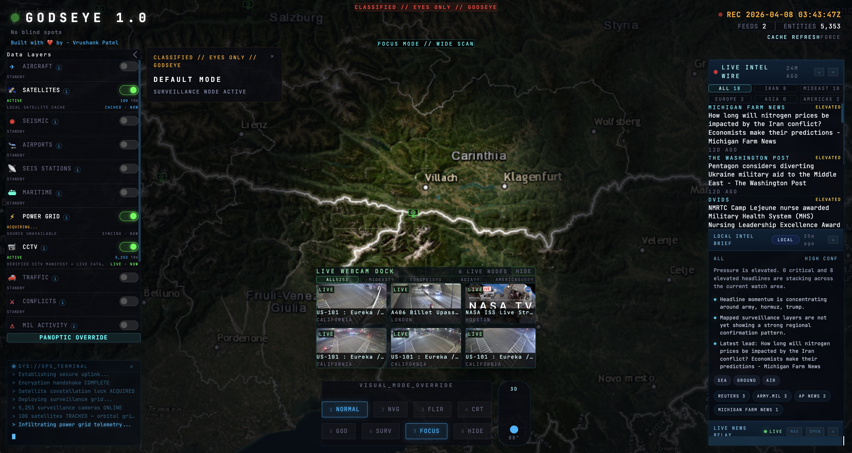
Godseye Geospatial HUD Preview
SYS.MODE: NVG ACTIVE
SENS: +24dB PHOSPHOR
SPECTRUM: 850nm IR
UTC: --:--:--
AZIMUTH: 184.22°
ELEVATION: 36.4°
LOC: METROPOLITAN SEGMENT
AGC: LEVEL 4 AUTO
BATT: 98.4%
FPS: 60.0 STABLE
FEED RATIO: 8/8 ENHANCED
REC ●
SYS.MODE: FLIR ACTIVE
WHITE-HOT THERMAL
LENS: f/1.2 50mm
UTC: --:--:--
RANGE: 4,821m
FOV: 45° X 30°
TEMP RANGE: 10°C - 85°C
EMISSIVITY: 0.95
AUTO-CAL: ON
T_MAX: 74.2°C
T_MIN: 12.1°C
FLIR CORE: V3
MONITOR: AMBER CRT
H-SYNC: 15.6 kHz
V-SYNC: 60 Hz
UTC: --:--:--
BAUD: 9600 bps
PARITY: NONE
SECTOR: GLOBAL OVERLAY
SCANLINE: PASS 1
MEM: 640KB BASE
TTY ACTIVE
VIDEO: NTSC TACTICAL
WARN: DEV CONSOLE OPEN
SYS.MODE: GOD MODE ACTIVE
FULL INTEGRATION ON
CELESTIAL ANCHOR: SET
UTC: --:--:--
SUBPOINT: GEO-LOCK
GRID REF: OSINT-1
FEEDS AUDIT: 100% ONLINE
RTDB CRYPTO LAYER: HYDRATED
BYOK INTEGRATION: EXPANDED
SAT PROPAGATING...
ADS-B MIL TRACKS: SCANNING
WARP INDEX: 1.0
Ready. Select a visualization mode to simulate HUD overlays.
Features Blueprint

Tactical Control Center

Interactive 3D Engine

Powered by CesiumJS. Fluidly interact with a global 3D map rendering topography, satellite coordinates, and dynamic tactical overlay markers in real time.

CesiumJS WebGL

Aviation Intelligence

Track live civilian flights globally using OpenSky Network/ADSB.lol, monitor tactical military air traffic, parse airport meteorological observations (METAR), and plot SIGMET/AIRMET weather hazard zones.

Live Feeds ADS-B

Space Domain Awareness

Propagate satellite orbits locally in the browser. Renders active satellite tracks from CelesTrak TLE manifests, displaying flight paths and overhead vectors.

Live Satellite JS

Live Camera Overlays

Access public CCTV and traffic cameras in real-time. Streams municipal webcams and major landmarks alongside live space telemetry feeds (e.g., NASA TV and ISS feeds).

Live HLS Webcams

Geological & Hazard Feeds

Tracks real-time earthquakes (USGS), global seismograph networks (IRIS), volcanic activity alerts (Smithsonian GVP), active thermal fires (NASA FIRMS MODIS), and extreme disaster alerts (GDACS).

USGS & NASA IRIS

Conflict & Infrastructure Layers

Overlays global armed conflict data geocoded from Wikidata SPARQL queries, power grid outage indicators (US DOE ODIN), global ports indices (WFP), and global power plant registry structures.

SPARQL WFP

BYOK Access Model

Bring Your Own Key architecture. Runs fully client-side without any backend database. Provides robust graceful degradation, enabling keyless features by default.

Keyless Ready Decentralized

Encrypted Shared Cache

Prewarm and cache slow-changing manifests (satellites, CCTVs, intel wires) inside an encrypted Firebase Realtime Database. Securely decrypted entirely on client-side.

Firebase RTDB AES Crypto
API Integration Matrix

Bring Your Own Key

Godseye degrades gracefully. Missing keys will disable individual data enrichments but will never crash the core dashboard.

VITE_GOOGLE_MAPS_3D_KEY Optional

Google 3D Photorealistic Tiles

Enables Google Earth-style photorealistic 3D city overlays when zooming into urban sectors. Falls back to default OSM buildings.

VITE_YOUTUBE_API_KEY Optional

CCTV Webcam Feeds

Used for discovery of real-time municipal streaming webcams and camera channels on YouTube to inject into the CCTV terminal panel.

VITE_GUARDIAN_API_KEY Optional

Intelligence Wire Feed

Powers real-time keyword-based news ticker updates, adding context to geopolitical anomalies occurring near visual coordinate indicators.

VITE_AISSTREAM_API_KEY Optional

Real-time Maritime AIS

Subscribes to live WebSocket ocean-faring vessel position streams, rendering active cargo, tanker, and service crafts globally.

VITE_FIREBASE_RTDB_URL Optional

Shared Runtime Database

Specifies the endpoint for the client-side encrypted Firebase Realtime Database to store prewarmed data manifests.

VITE_GODSEYE_CACHE_SECRET Optional

Client Encryption Key

AES decryption key for the shared Firebase cache data. Required to hydrate/decrypt telemetry data fetched from the cache.

Local Deployment

Quick Start

zsh — terminal
# 1. Clone repository
git clone https://github.com/VrushankPatel/godseye.git
cd godseye

# 2. Set up local keys configuration (see BYOK list)
cp scripts/local-secrets.example.sh scripts/local-secrets.sh
# Edit scripts/local-secrets.sh with your text editor

# 3. Install packages
npm install

# 4. Start local development HUD
./scripts/with-local-secrets.sh npm run dev
# Build production bundles with injected secrets
./scripts/with-local-secrets.sh npm run build

# Preview locally on port 4173
./scripts/with-local-secrets.sh npm run preview
# Force pre-warm and publish the encrypted client cache payload
# to the designated Firebase RTDB endpoint
./scripts/with-local-secrets.sh npm run shared-cache:publish
Integration Mapping

Telemetry Sources

Godseye utilizes free public streams and coordinates fallback mechanisms to ensure high resilience under heavy payload limits.

OpenSky Network API Aviation
GET /api/states/all

Provides dense real-time air traffic monitoring. Aggregated with fallback mapping via ADSB.lol keyless ADS-B mirrors for tracking military aircraft callsigns.

CelesTrak Catalog Space
GET /pub/TLE/catalog.txt

Delivers Two-Line Element (TLE) tracking sets. Allows direct client-side SGP4 orbital propagation of active space systems in the browser.

USGS Earthquake Hazards Geological
GET /earthquakes/feed/v1.0/summary/...

Queries live seismic movements and magnitudes worldwide. Automatically falls back to IRIS text parses if USGS servers fail.

NASA EONET Feeds Geological
GET /api/v3/events

Coordinates geospatial indicators of extreme environmental disturbances: volcanic flows, heavy floods, severe storms, and active wildfire events.

GDACS Alerts Geological
GET /xml/rss.xml

Provides early-warning coordinates and impact grids for major natural catastrophes including cyclones, droughts, floods, and earthquakes.

Wikidata SPARQL Infrastructure
POST /sparql

Fetches geocoded entities for ongoing active conflicts, disputes, and regional military base coordinate indicators.

NOAA Buoy Telemetry Weather
GET /data/latest_obs/latest_obs.txt

Parses global weather buoys telemetry (wave heights, water temperatures, barometric changes, wind speeds) using client CORS proxies.

Open-Meteo API Weather
GET /v1/forecast

Supplies dense meteorological grids, aerosol data, particulate densities (PM2.5, PM10, ozone), and localized forecast grids dynamically.

US DOE ODIN Infrastructure
GET /data/outages.json

Monitors grid security, grid overload statistics, and major county-level power grid outage alerts across the US.